

The West’s historic drought in 3 maps
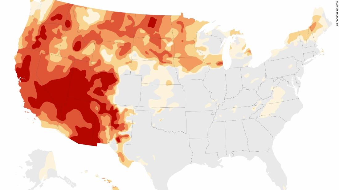
More than 95 percent of the West is in some level of drought, with nearly two-thirds in extreme or exceptional drought — the two worst categories. Six states are entirely in drought conditions.
Scientists say the unprecedented, multi-year drought is a clear sign of how the climate crisis is affecting not only the weather, but water supply, food production and electricity generation.
Across the US, the drought has nearly doubled in size from this time last year. Around 25% of the country was in drought conditions in July 2020; as of this week, nearly half the US is in drought.
The West is experiencing historically dry conditions, with more than 95% of the region drought, the largest area on record. ‘Extreme’ or ‘exceptional’ drought — the two most severe categories — covers 65% of the West and expanded by more than 60,000 square miles, or about the size of the state of Georgia, during the month of July.
In California, exceptional drought expanded by one third week-over-week, and now covers nearly 50% of the state, up from just 1% at the beginning of 2021. The population of California within that category increased by more than 50% this week, and now covers nearly 14.5 million people.
Oregon also saw significant expansion its drought — just under 25% of the state is covered by exceptional drought, the most in the state’s history.
Similarly in Washington, the area in exceptional drought is at record high and now covers more than one-third of the state. Prior to this month, exceptional drought had never been observed in Washington in the 21-year history of the Drought Monitor.
There are six states completely in drought conditions: California, Oregon, Nevada, Utah, Idaho and North Dakota.
As the planet warms, drought and extreme heat will also fuel deadly wildfires. Multiple studies have linked rising carbon dioxide emissions and high temperatures to increased acreage of burning across the West, particularly in California.
Rainfall outlook
The West experienced extremely low rain and snowfall over the past year, compounded by drastically high temperatures. Less rain and increasing heat waves have led directly to drought conditions and water shortages.
The Southwest monsoon, which began in mid-July, has lead to some relief in the region. Robust monsoon rainfall in the last weeks of July made a dent in the drought conditions, improving classifications across several states.
“In Arizona, Tucson received more rain in 6 days than during all of 2020, when annual precipitation of 4.17 inches was the lowest on record,” according to the US Drought Monitor.
In addition to Arizona, improvement was noted in parts of New Mexico, southwestern Colorado and southern portions of Utah and Nevada.
As climate change accelerates and winter temperatures increase, snowfall will decrease. High-elevation snowpack serves as a natural reservoir that eases drought, storing water through the winter months and slowly releasing it through the spring melting season.
Stream and river flow
Streamflow, a measure of how much water is carried by rivers and streams, is another significant indicator of drought and its impact.
As drought conditions have worsened in 2021, hundreds of stream and river locations are experiencing below-average flow. More than 50 percent of the western monitoring stations reported lighter-than-usual flows. Fishing restrictions have also been put in place on many rivers in Montana due to low flows and warm waters.
Changes in streamflow affect the water supply for our own municipal use, crop irrigation and power generation.
![]()