

London on RED alert for Storm Eunice: Now Met Office issues most extreme weather warning for capital
London on RED alert for Storm Eunice: Now Met Office issues most extreme weather warning for capital and South East as 100mph ‘sting jet’ tempest hits with schools closed, trains and flights cancelled and people warned to stay indoors
Two red warnings issued for southern England for 7am-12pm in South West and 10am-3pm in South East Met Office warns of ‘flying debris resulting in danger to life’, ‘roofs blown off’ and power lines down Hundreds of schools close, all trains in Wales suspended and rail passengers in England told not to travelBritish Airways cancels dozens of flights and major attractions including London Eye and Legoland close
<!–
<!–
<!–<!–
<!–
(function (src, d, tag){
var s = d.createElement(tag), prev = d.getElementsByTagName(tag)[0];
s.src = src;
prev.parentNode.insertBefore(s, prev);
}(“https://www.dailymail.co.uk/static/gunther/1.17.0/async_bundle–.js”, document, “script”));
<!–
DM.loadCSS(“https://www.dailymail.co.uk/static/gunther/gunther-2159/video_bundle–.css”);
<!–
Millions of Britons were urged to stay at home today amid travel chaos after the Met Office issued a rare ‘red warning’ for 100mph winds over southern England including London as Storm Eunice swept into Britain.
The warnings run from 7am until 12pm in the South West and 10am until 3pm in the South East with forecasters concerned over ‘flying debris resulting in danger to life’ as well as ‘roofs blown off and power lines brought down’.
Hundreds of schools were closed, all trains in Wales were suspended and rail passengers across England were told not to travel amid mass cancellations as the Army was on standby for what could be the worst storm in 32 years.
British Airways cancelled more than 80 flights at London Heathrow and City airports, motorists were warned only to make essential journeys and major attractions closed including the London Eye, Kew Gardens and Legoland.
The Met Office issued the first red warning for the South West at 11am yesterday, 20 hours in advance, before issuing the second for the South East at 4am today – just six hours before the ‘extremely strong winds’ begin.
The South West warning covers coastline of Devon, Cornwall and Somerset as well as South Wales due to the combination of high tides, strong winds and storm surge – while the second is over most of South East England.
Top wind speeds could hit 100mph with the strongest gusts expected in exposed coastal areas, while a lesser amber warning for gusts up to 80mph covers the whole of England until 9pm tonight having started at 5am.
The Met Office added that the phenomenon known as a sting jet – a small area of highly intense wind inside a storm – could form later today. It would be the first instance of such an event since the Great Storm of 1987.
Forecasters today urged Britons to work from home in the worst affected areas – with the centre of the storm expected to be up the Bristol Channel and around the narrowing of the River Severn in Gloucestershire.
The top wind gusts recorded as of 8am were 77mph on the Isles of Scilly, 75mph at Capel Curig in North Wales and 71mph at Needles on the Isle of Wight. Meanwhile in a string of weather-related developments:
Most schools across the worst hit regions in the South West and Wales announced they will shut today;Major UK attractions including Windsor Castle, London Zoo and Chessington World of Adventures closed;Windsor Great Park, Richmond, Bushy and Greenwich Parks in London all said they would shut to the public;Network Rail warned disruption was ‘inevitable’ with airports advising people to check flights with airlines;People were urged not to take dangerous ‘storm selfies’ with huge waves expected along the south coast;The Environment Agency issued 10 severe flood warnings, 31 normal flood warnings and 102 flood alerts;In some areas, refuse collections were cancelled and residents warned to ‘tie down’ bins in the back garden;Pet owners were warned to take extra precautions to keep their animals safe during the storm.
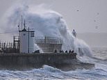
Waves crash against the harbour wall at Porthcawl in South Wales this morning as Storm Eunice sweeps into Britain
Waves hit Porthleven on the Cornish coast this morning as Storm Eunice makes landfall in the South West
Large waves strike the coast of North Devon at Ilfracombe this morning as Storm Eunice sweeps into Britain
Strong waves hit the coast of South Wales at Swansea this morning as Storm Eunice sweeps into Britain
Large waves strike at Newquay in Cornwall this morning as Storm Eunice sweeps into Britain
Strong waves hit Wembury in Devon this morning as Storm Eunice strikes Britain after a series of red warnings were issued
People watch the waves hitting the coast of Somerset at Clevedon this morning as Storm Eunice strikes Britain
Waves hit Porthleven on the Cornish coast this morning as Storm Eunice makes landfall in the South West
Forecasters warned that the strength of the winds over Britain could be worsened by a rare weather feature called a ‘sting jet’
People should ‘take precautions’ during Storm Eunice, the Government has said, adding that the Army is on ‘high readiness standby’ to help.
Home Office minister Damian Hinds told Sky News: ‘We are strongly encouraging people to take precautions and make sure they stay safe.’
He added: ‘Over the longer term a lot of learning has been done from Storm Arwen, particularly on dealing with welfare issues, staying in touch with people, staying in touch with customers for the (power) networks.
‘But in the immediate term there are troops on high readiness standby, the Environment Agency on the ground, the networks themselves have to be very much active, and they are.
‘Weather is unpredictable and it is really important that we all continue… to take those precautions and try to keep everyone safe.’
Asked if people could get ‘cut off’ by the storm, Mr Hinds said that was ‘absolutely a risk’, and the red weather warning indicated a ‘risk to life and limb’.
It comes as millions of people were today told to stay indoors, cancel travel plans and stay away from the coast as Storm Eunice sweeps across the country from the early hours.
Families have been warned to expect falling trees, flying debris, severe flooding, roofs blown off and downed power lines.
There are also fears of blocked roads and rail routes, disruption to flights and the threat of 40ft waves on Britain’s shores.
Forecasters are especially worried because the storm is hitting during the morning rush hour – and in heavily populated areas.
Last night, much of the country began closing down in anticipation of its arrival. Some rail and bus networks announced they would shut completely.
Several popular attractions will be closed, as will many parks because of the risk of falling trees.
A motorist struggles to deal with the difficult driving conditions in Consett, County Durham, this morning
Snow falls in Scotland against a backdrop of Edinburgh Castle as Storm Eunice sweeps across the UK this morning
A motorist struggles to deal with the difficult driving conditions in Consett, County Durham, this morning
Storm Eunice arrives in Paisley in Scotland as commuters make their way through the heavy snow on the way to work
A motorist clears his car of snow amid difficult driving conditions in Consett, County Durham, this morning
Storm Eunice arrives in Paisley in Scotland as commuters make their way through the heavy snow on the way to work
A snowplough clears a road in Tow Law, County Durham, this morning as Storm Eunice sweeps across the UK
Snow falls in Burnopfield in County Durham this morning, covering roads, paths and vehicles as Storm Eunice arrives
A snowplough clears a road in Tow Law, County Durham, this morning as Storm Eunice sweeps across the UK
Snow falls in Burnopfield in County Durham this morning, covering roads, paths and vehicles as Storm Eunice arrives
A person clears snow in Tow Law, County Durham, as Storm Eunice sweeps across the UK this morning
Snow falls in Burnopfield in County Durham this morning, covering roads, paths and vehicles as Storm Eunice arrives
A lorry drives through falling snow in Tow Law, County Durham, today as Storm Eunice sweeps across the UK
A person clears snow in Tow Law, County Durham, this morning as Storm Eunice sweeps across the UK
Heavy snow fall in Tow Law, County Durham, this morning as severe weather conditions sweep into Britain
Meanwhile ministers held a meeting of the Government’s crisis Cobra committee yesterday amid fears Eunice could be the worst storm to hit Britain since the Burns’ Day storm in 1990 which killed almost 50 people, or the Great Storm of 1987, which felled countless trees and claimed 18 lives in England.
Storm Eunice comes just hours after Storm Dudley brought down power lines, leaving more than 20,000 properties in the North of England blacked out.
Boris Johnson yesterday confirmed the Army was on standby to help Britain cope with the impact of Storm Eunice, with the Government ready to offer ‘all the support we can’.
The Met Office urged workers to cancel commutes and to work from home in the worst affected areas.
Forecaster Becky Mitchell said: ‘With the wind gusts we are forecasting at the moment, we’ve only seen a handful of storms in the past 30 years that have brought similar gusts.
‘It’s got the potential to be up there as quite a notable storm. Winds are likely to be 60 to 70mph inland across the south of the UK. It’s quite unusual, we don’t see gusts that high over such a wide area in the south. The Burns’ Day storm brought similar gusts.’
Dr Ambrogio Volonte of the University of Reading said the storm has the same structure as the 1987 one which could result in a ‘sting jet’ – winds of 100mph or more which descend rapidly to the ground leaving devastation in their wake.
The conditions will also coincide with high tide sparking massive waves which prompted warnings to stay clear of coastal paths.
Network Rail executive Jake Kelly, the group director for system operator, told BBC Radio 4’s Today programme this morning: ‘We very, very strongly advise passengers not to travel. It’s going to be a very difficult day.
‘Fundamentally it’s right to expect lots of trees will be blown down and there’ll be other damage. There will be a lot of disruption. We are going to run a service for those who absolutely need to travel but it’ll be disrupted.
‘In a small number of places there are no trains at all – The South West coast and parts of Wales. Elsewhere we are expecting to run a disrupted service. Two pieces of advice, be prepared for very significant delays and second check your train is running at all.’
Met Office chief meteorologist Paul Gundersen said: ‘After the impacts from Storm Dudley for many on Wednesday, Storm Eunice will bring damaging gusts in what could be one of the most impactful storms to affect southern and central parts of the UK for a few years.’
‘The red warning areas indicate a significant danger to life as extremely strong winds provide the potential for damage to structures and flying debris.’
There was also a yellow wind warning until 6pm tonight in northern England and southern Scotland, while a separate yellow warning for snow covers Scotland, Northern Ireland and northern England until the same time.
The Met Office also took the unusual step of issuing a 12-hour severe weather alert with National Highways for strong winds covering the whole of the country’s strategic road network from 6am today until 6pm tonight.
National Highways said high-sided vehicles and other ‘vulnerable’ vehicles such as caravans and motorbikes could be blown over so should avoid bridges and viaducts.
National Highways head of road safety Jeremy Phillips urged those travelling to ‘plan your trip and take extra care, allowing more time for your journey’.
He said: ‘In high winds, there’s a particular risk to lorries, caravans and motorbikes so we’d advise drivers of these vehicles to slow down.
‘Drivers of other vehicles should be aware of sudden gusts of wind which can affect handling and braking, and give high-sided vehicles, caravans, and motorbikes plenty of space. In the event of persistent high winds we may need to close bridges to traffic for a period, so please be alert for warnings of closures and follow signed diversion routes,’ he added.
The Environment Agency issued 11 severe flood warnings along the River Severn near Gloucestershire, South Wales and Somerset, meaning there is a danger to life. It also issued 31 normal flood warnings and 102 flood alerts across England.
Environment Agency flood duty manager Katharine Smith said: ‘Strong winds could bring coastal flooding to parts of the west, south-west and south coast of England, as well as the tidal River Severn, in the early hours of Friday morning. This is due to Storm Eunice resulting in high waves and potential storm surge coinciding with the start of a period of spring tides.’
Those travelling between England and Wales overnight faced difficulties with the closing of the Severn Bridge, while the alternative Prince of Wales bridge was expected to be closed about 6am.
Flooding in Birmingham city centre today as Storm Eunice results in a series of weather warnings being issued across Britain
Flooding in Birmingham city centre today as Storm Eunice results in a series of weather warnings being issued across Britain
Flooding in Birmingham city centre today as Storm Eunice results in a series of weather warnings being issued across Britain
Flooding in Birmingham city centre today as Storm Eunice results in a series of weather warnings being issued across Britain
National Highways announced the Orwell Bridge in Suffolk was closed in both directions with the Dartford Crossing joining it in shutting about 5am.
People have been warned to ‘tie down’ objects in their gardens and be wary of fierce winds which could cause trees to topple over and tiles to fly off buildings.
A number of attractions including the London Eye, Legoland and Warwick Castle are temporarily closing.
A Network Rail spokesman said disruption is ‘inevitable’ and Welsh services will be suspended for the whole day, while London North East Railway urged customers with tickets for Friday to travel on Saturday instead or get a refund due to expected disruption and damage.
East Midlands Railway said trains to and from London St Pancras ‘may be withdrawn at short notice’, National Rail said there would be no trains between Nottingham and Skegness until about 8am, and Northern said it was advising customers ‘NOT TO TRAVEL across the Northern network’.
Transport for Greater Manchester has asked customers to ‘please consider whether your journey is essential today and take care if you are out and about’.
The operator said Storm Eunice was ‘likely to cause significant disruption due to extremely strong winds today’ across the region from 5am until 9pm.
And a council leader has said his area is ‘braced for impact’ as Storm Eunice touches down in the South West.
The deputy leader of North Somerset Council, Mike Bell, said most schools in the area were closed and public transport had already been disrupted by the extreme weather.
The Liberal Democrat councillor for Weston-Super-Mare Central told BBC Breakfast: ‘We’ve got teams on standby to tackle fallen trees, blocked roads, flooding, and any issues.’
Mr Bell added: ‘Yesterday obviously as soon as the red alert was issued we issued advice to our schools to close, so most of our schools are closed today.
‘We’ve closed off the sea front, we’ve got very good sea defences here in Weston-Super-Mare and in other parts of the North Somerset coast so we’ve closed off those sea fronts.
‘We know that travel and transport is already disrupted and suspended for most of the morning and I think the message is very firmly: stay at home if you possibly can, baton down the hatches and wait for Eunice to pass over.’
It comes after Storm Dudley caused travel disruption and power cuts to parts of the UK on Wednesday.
![]()