

August was the third cloudiest month on record for Southern England
Grey Britain: Gloomy August was the third cloudiest month on record for Southern England, Met Office confirms (and don’t hold your breath for a sizzling September)
August set to go down as the third cloudiest month on record for Southern England as dull weather continues Data shows the region received only 129 hours of sunshine this month compared to its average 192.5 hoursEast Anglia also experienced third cloudiest August on record with the area seeing just 127.2 hours of daylight
<!–
<!–
<!–<!–
<!–
(function (src, d, tag){
var s = d.createElement(tag), prev = d.getElementsByTagName(tag)[0];
s.src = src;
prev.parentNode.insertBefore(s, prev);
}(“https://www.dailymail.co.uk/static/gunther/1.17.0/async_bundle–.js”, document, “script”));
<!–
DM.loadCSS(“https://www.dailymail.co.uk/static/gunther/gunther-2159/video_bundle–.css”);
<!–
August is set to go down as the third cloudiest month on record for Southern England as forecasters predict heavy wind and rain will continue to lash parts of the nation into September.
Figures from the Met Office show Southern England experienced its third dullest August since records began in 1957, beaten only by 2008 and 1950, with the region receiving only 129 hours of sunshine this month compared to its usual average of 192.5 hours.
Meanwhile East Anglia also experienced the third cloudiest August on record with the area seeing just 127.2 hours of daylight compared to the average 195.7 hours usually seen during the month.
For the UK overall – August was the 12th dullest on record with 127.4 hours of sunshine – the figure is 78 per cent of the 163 hours of sun usually seen.
Despite the gloomy weather, Tyndrum in Stirling, Scotland, recorded the highest temperature in the UK so far this month after it hit 80.2F on August 25.
It comes as Britain braces itself for more heavy wind and rain to lash parts of the nation next month during an ‘unsettled’ September, with an area of low pressure set to sweep over this nation this Sunday.
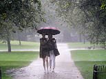
August is set to go down as the third cloudiest month on record for Southern England since records began in 1957. Pictired: Two women walk through heavy rain in St James’s Park in central London
This region received only 129 hours of sunshine this month compared to its usual average of 192.5 hours, figures from the Met Office show. Pictured: Clouds loom over Brighton in East Sussex
For the UK overall – August was the 12th dullest on record with 127.4 hours of sunshine – the figure is 78 per cent of the 163 hours of sun usually seen. Pictured: Sailboats moored on Lake Windermere
Large swathes of people across England will catch their last chance to soak up the summer rays for the year this week, with only brief ‘glimpses of sunshine here and there’ ahead of a miserable month.
The Met Office has put this down to an area of low pressure moving in from Sunday, combined with the effects of ‘increased tropical storm activity’ in the US.
It comes amid unsettled weather which has persisted across the UK throughout August, with the weather service also naming its first storm of the summer – Storm Evert – last month.
Despite the soggy outlook, bookmaker Coral has slashed the odds from 3-1 to 6-4 on next month being a record hot September in the UK, saying early reports suggest it will be ‘warmer than average’.
Last month, the south of England saw one of the dullest and wettest summers in ten years while the north of England and Scotland experienced unusually warmer temperatures and its driest summer since 1869.
The capital and central England, which saw temperatures that were only 0.25C higher than the long-term average, also saw regions flooded after heavy rain and thunderstorms swept over the south of the country.
Met Office data also showed the City of London saw 117 per cent of its usual August rainfall by August 22.
Alex Burkill, a Met Office forecaster, said: ‘It’s fair to say the beginning of the month will be rather settled, with high pressure dominating.
‘There will be drizzle and cloud in the east this week, but in the west certain regions will certainly hit the low 20s and see glimpses of sunshine here and there.
‘However, this could perhaps be the last of the summery weather until the end of September, with a prolonged spell of unsettled conditions and low pressure from Sunday.’
Mr Burkill warned that September is likely to see ‘more rain and wind’ than in August, which was wetter than average in parts of the South East and London.
He added: ‘The low-pressure, along with the increased tropical storm activity across the Atlantic will certainly give the month a more autumnal- feel than previous years.
Beach-goers make the most of an overcast afternoon at the seaside resort of West Bay in Dorset on August 31
One man leans over the cliff edge as he enjoys an overcast afternoon at the seaside resort of West Bay in Dorset today
People zip wire across the sea from Bournemouth pier towards the beach earlier this month. Despite the soggy outlook, bookmaker Coral has slashed the odds from 3-1 to 6-4 on next month being a record hot September in the UK
Revellers sit on the beach at West Bay in Dorset as the region is left overcast with grey clouds and forecasters predicts more rain and wind
‘The temperature is likely to remain around the average for the year, perhaps dipping a bit cooler until the end of the month – when it may well get drier again.’
It comes after parts of the UK have seen large amounts of rainfall for the time of year, including the City of London, which has experienced its ninth wettest August on record.
Heavy rain and hail has already caused ‘significant problems’ for harvests, according to the National Farmers Union (NFU).
A spokesperson for the union said this year’s harvest was delayed due to cold spring temperatures, but it’s too early to say how much profits will be impacted and whether consumers could see a rise in food prices.
They said: ‘The localised heavy rain and hail has caused significant problems in certain areas.
‘It’s a mixed picture because for many areas they just haven’t had many clear dry days in a row to harvest, so things have been a bit ‘stop-start’ with harvesting.
‘Where they have been harvesting, grain has often had to be dried because the better weather hasn’t lasted long enough to get moisture levels down to where they need to be.
‘The problems will grow if the unsettled weather continues because it will start to impact on the quality of the grain if it goes on too long, especially for crops like milling wheat.’
![]()